Henry Charting System
Visit our dedicated Henry support pages
Henry is a robust, feature-rich Geographic Information System (GIS) trusted by some of the maritime industry's biggest names. Henry offers a unique mix of geospatial and cartographic functionality that has found dedicated users in all corners of the marine industry, from hydrographic offices and cartographers to shipping companies and navigators.
If you have complex data to visualise or need to manage thousands of pieces of data, Henry is exceptionally good at displaying it clearly and quickly, giving meaning to your data.
Henry runs on Microsoft Windows XP or later (including Windows 8.1).
Advantages
- Displays information over lots of different chart types at the same time
- Overlay georeferenced aerial or satellite imagery on charts
- Stores, assesses and brings together hundreds of pieces of raw data quickly and easily
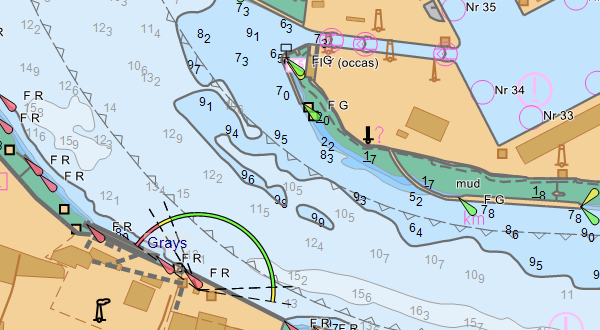
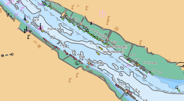
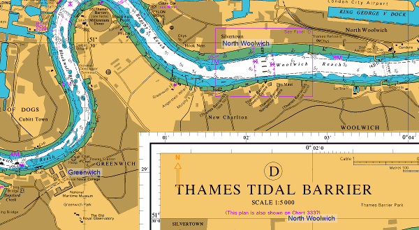
- Simplifies digital chart management and displays ARCS charts undistorted
- Displays almost all types of charts and supports a wide range of chart formats
- Integrated Tides Database and Pay As You Sail functionality
- Simultaneous viewing of the same file set by multiple users
- Zoom and pan the display at the same time
Example applications
- Route planning for large vessels and containers in the oil industry
- Fleet vessel monitoring for off-shore industries, such as work boats servicing wind farms
- The verification of new chart data by hydrographic offices
As a GIS system with a marine focus
The accurate geodesy and attention to detail in Henry makes it popular with hydrographic offices for verifying new chart data. Henry is one of the only chart tools to display ARCS charts undistorted, using the original projection and including the original marginalia.
Henry has comprehensive support for chart data formats, datums and grids. It supports a variety of sources of geospatial data, and can overlay georeferenced aerial or satellite imagery on charts.
Henry can display AIS and ARPA data from NMEA files, and geospatial data stored in spreadsheets. For more complex needs, Henry has an SDK that allows the import and export of data to be automated.
Contact us to learn more about how Henry can bring your marine data to life, or download a demonstration version.
For fleet management and monitoring
Achieve unprecedented insight by using Henry to integrate live position data with piracy and navigational safety reports. This data enables proactive decision-making and risk management.
Henry can receive and plot position updates from your fleet via ARPA, AIS or various satellite communication systems, giving your organisation real-time visibility into fleet operations.
Contact us to discuss how Henry can meet your needs for fleet management and monitoring, or download a demonstration version.
At sea
NMEA GPS integration and support for route planning and monitoring means that Henry can be a key asset on any ship's bridge.
Support for ADMIRALTY Digital Publications puts crucial navigational information at the mariner's fingertips.
Intelligent decluttering promotes situational awareness by prioritising information the mariner needs.
Henry can plot and monitor efficient search patterns for seaborne and airborne search and rescue operations.
Contact us to learn more about how Henry can help mariners make the best possible decisions, or download a demonstration version.
For ENC management and updating
Sail through port state inspections with automatic management of your ENC portfolio.
Henry uses our Universal Chart Server, bringing together the latest ENCs from AVCS, PRIMAR® and NOAA® and delivering them seamlessly to your vessel or onshore operations centre. Our patented ENC compression technology enables onboard chart portfolios to be updated efficiently, saving on time and bandwidth costs.
Contact us to learn more about how Henry can simplify management of your digital nautical charts, or download a demonstration version

Supporting digital chart production
Supported chart formats
ENC, S63, ARCS, AML, NTF, HCRF, Shapefiles, BSB, ASRP, CRP, GRP, CADRG, CIB, GeoTIFF, VPF (DNC, VMap, UVMap), manually georeferenced images such as aerial photographs.Henry is a powerful tool for quality assurance of digital charts.
Henry can display S-57 ENCs in strict accordance with the ECDIS performance standards, allowing digital cartographers to test and verify their ENCs during production. Aerial photographs, satellite imagery, and other sources of data can be overlaid onto ENCs, making quality assurance less onerous and more rigorous.
Contact us to discuss how Henry meets the needs of hydrographic data producers, or download a demonstration version.
Comprehensive and adaptable toolkit
Henry is a comprehensive toolkit, consisting of many parts that can be used in a wide range of applications in the marine industry.
You can purchase Henry as a complete, ready-made system or as a custom-built system from a combination of parts of Henry.
Dedicated support
If you need any help installing or using Henry, we have a dedicated support website, which you can find here.
Our expertise
We are experts in designing software for the marine industry. Read about how our expertise relates to Henry:
- Chart drawing
- Data management and workflow
- Marine data distribution
- Real time navigation
- Voyage planning
Contact us
Contact us to discuss how Henry can meet your marine needs.